
Carta dell Isole di Capo Verde con l'Isole dell Indie occidentale et parte della Terra ferma di Guiana. . . Carta V
Robert Dudley / 1646/1661
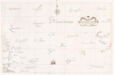
The illegitimate son of the Earl of Leicester, one of Queen Elizabeth I’s favorites, Robert Dudley produced his monumental sea atlas, Dell’Arcano del Mare, while in exile in Florence. This rare Atlantic Ocean chart is a wonderful example of Dudley’s cartography and the artistry of his engraver, Antonio Lucini. It shows a stretch of the Atlantic extending from the Cape Verde Islands off the West African coast to the Lesser Antilles, from Sombrero (Hat) Island and Anguilla to Trinidad, and the mouth of the Orinoco. The chart's highly decorative features include a galleon at sea, a compass rose, an elegant marine-motif title cartouche, and the supremely elegant calligraphy that is a trademark of Dudley's charts.
First published in 1646, Dudley's Arcano del Mare was the first sea atlas of the whole world and the first to use Mercator's projection. This exemplar is from the second (and only other) edition issued in 1660. For more on the life and times of Sir Robert Dudley and the significance of his masterwork sea atlas, see this overview from the archives of Windsor Castle's College of St. George.