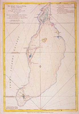

Turks Islands from a survey made by the Sloops L'Aigle and L'Emeraude, by Order of the French Governor of Hispaniola.
This item has been sold.
Please check our homepage for currently available maps.
A superb, large-scale chart of the Turks, by one of the leading London map publishers of the turn of the 19th century. The chart includes depth soundings, shoals, reefs, and anchorages, as well as two sets of nautical observations in the upper right and lower left corners of the sheet. Please check our homepage for currently available maps.
Item Number: 450
Cartographer: Laurie & Whittle
Place & Date: London / 1810
Size: 12 1/4" x 18"
Condition:
Price: SOLD