use +/- or mouse scrollwheel for magnification.
click here
for full-sized image.

Colton's Central America.
This item has been sold.
Please check our homepage for currently available maps.
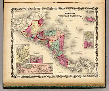
A slightly later and more intensely colored edition of Colton's Central America map, published by the firm of Johnson & Browning, instead of Colton's own firm. Scattered throughout the map are small text blocks on the new boundaries of Belize, Mosquito, and Costa Rica and on the proposed Honduras Interoceanic Railway. Also included are five inset maps of the Isthmus of Panama, the Harbor of San Juan de Nicaragua, the "Nicaragua Route," Manzanilla Island (in Panama) and the City of Panama. A beautiful scrollwork border surrounds this information-rich example of mid-19th century American cartography. Please check our homepage for currently available maps.
Item Number: 137
Cartographer: J.H. Colton / Johnson & Browning
Place & Date: New York / 1858
Size: 15 1/2" x 13"
Condition: Overall age toning and some spotting in margins; slight tears in margins, well repaired
Price: SOLD