
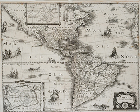
America noviter delineata
This item has been sold. Please check our homepage for currently available maps.
A strong, dark impression of Merian's large Western Hemisphere map derived from the 1618 Americas map by Jodocus Hondius and published in J.L. Gottfried's compilation of exploration narratives first published by de Bry. The Merian map features a wealth of place names and topographical details, a pair of vignettes in South America, a number of sea monsters and sailing vessels, a prominent equatorial line, and inset maps in Greenland and the North Pole and of Antarctica. An important and uncommon Americas map in a beautifully preserved exemplar. Item Number: zk1621
Cartographer: Matheus Merian
Place & Date: Frankfurt / 1631
Size: 17 1/2" x 14"
Condition: b&w; a few minor spots, some browning along margins
Price: SOLD