
Descripcion de las Indias Ocidentales
This item has been sold. Please check our homepage for currently available maps.
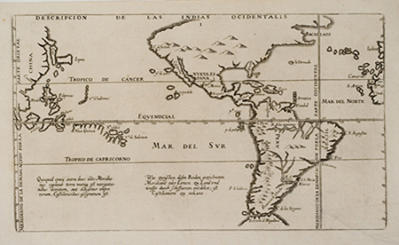
De Bry's rare reduced edition of Herrera's influential map of the Americas and the Pacific, from volume 12 of the Grand Voyages. The territory described by the map extends from the west coast of Iberia and North Africa to the east coast of China, with in between, the Americas (from Bacallaos, or Cape Cod, to the Straits of Magellan), several Pacific Island groups (Galapagos, Salomon, Ladrones, Moluccas, Philippines), and Japan, Korea, and eastern China. The Latin and Germans texts at the bottom of the map describe the demarcation line between the Spanish and Portuguese New World claims set by the Treaty of Tordesillas. A scarce and important New World map. Item Number: rs1651
Cartographer: Herrera / de Bry
Place & Date: Frankfurt / 1623
Size: 11 3/4" x 6 3/4"
Condition: b&w; washed; a tear at lower right corner of margin extending into image, expertly restored; back with Japan paper.
Price: SOLD