
Nord-Americanische Freistaaten
This item has been sold. Please check our homepage for currently available maps.
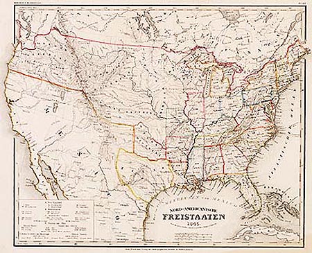
A fascinating map of the United States just prior to the Mexican-American War with an independent Texas whose southern border is still the Nueces River; from the 1845 edition of Meyer's Hand-Atlas. The numbered and lettered key at the lower left corner identifies the various states and territories ("districts") by region and by slave-holding status: New England, Middle, Southern, States on the Ohio ("Slave States" and "States without Slaves") and States west of the Mississippi ("Slave States"). Mexico at its fullest extent is bordered by Texas and the Ozark, Osage, Mandanen and Oregon territories of the United States. An important record of a critical moment in U.S. and Mexican history. Item Number: G681
Cartographer: Bibliographisches Instituts.
Place & Date: Hildburghausen / 1845
Size: 14 3/4" x 11 1/2"
Condition: original outline color; water stain along lower margin affecting lower right corner of image; tear in lower left margin.
Price: SOLD