
use +/- or mouse scrollwheel for magnification. click here for full-sized image.
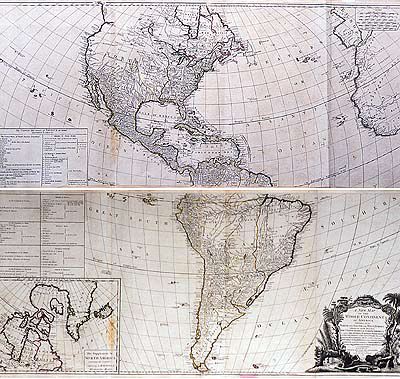
A New Map of the Whole Continent of America Divided into North and South and West Indies wherein are exactly Described the United States of North America.
This item has been sold. Please check our homepage for currently available maps.
Gibson's celebrated two sheet map of the New World, showing the recently recognized boundaries of a United States still in its infancy. Superbly detailed and impressive in its size and beauty of design, the map is based on d'Anville's Americas maps, as well as recent Spanish explorations in northern California and the cartographic research of Governor Pownall in English North America. Although the United States extends to the Mississippi, the province of Quebec appears to encroach on U.S. territory around the Great Lakes. Details of northwestern North America are just beginning to emerge. The map shows a peninsular California, a Chinese colony ("Fou Sang") in British Columbia, and two possible locations for a "River of the West" (one with its source at Pike's lake; the other, further north at Lake Winnipeg). The South America sheet includes an inset map of northern North America to Baffin's Bay, showing Greenland as part of the North American mainland. Running through both sheets is a listing of the states of the United States and the American possessions of the various European colonial powers. The enormous title cartouche is a baroque fantasy with New World flora, both temperate and tropical, a beaver, a alligator, and an Indian chieftain's headdress. Item Number: G123
Cartographer: J. Gibson / R. Sayer
Place & Date: London / 1786
Size: 46 1/2" x 20 1/4" (each sheet).
Condition: outline color, cartouche in b&w; some minor browning along folds
Price: SOLD