
Allgemeine Historie der Reisen zu Wasser und zu Lande
This item has been sold. Please check our homepage for currently available maps.
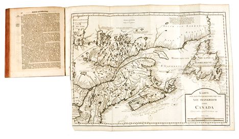
Volume 14 of the German derivative of Prevost d'Exile's influential collection of travel narratives, Histoire Generale des Voyages, is devoted to French North America and contains a complete set of 18 maps and plans based on Bellin: North America, Acadia, the Coasts of French Florida (the Carolinas), the Richelieu River, Montreal Island, Newfoundland, the Bay, Roads, and Harbor of Plaisance, New France (a magnificent folding map measuring 21 1/2" x 15 1/2"), Hudson's Bay, the end of Hudson's Bay, Louisiana (Mississippi Basin), plan of Port Royal, plan of La Haive harbor, plan of Milfort harbor, Isle Royale, plan of Louisburg, plan of Dauphin harbor, and plan of New Orleans. Item Number: B1904
Cartographer: Arkstee und Merkus
Place & Date: Leipzig / 1756
Size: 7 5/8" x 9 1/2" (overall volume; dimensions of individual folding maps vary)
Condition: original gold-stamped leather binding, worn and scuffed but intact; overall age toning and some overprinting on text pages and folding maps; Richelieu River and Lake Champlain map is darker than the rest, which are otherwise in excellent condition
Price: SOLD