
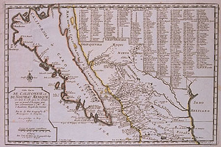
Cette Carte de Californie et du Nouveau Mexique est tiree de cell qui a ete envoyee par un grand d'Espagne.
This item has been sold. Please check our homepage for currently available maps.
The rare first edition of a remarkable map from De Fer's Atlas Curieux, showing California (or the New Carolinas) as an island and the adjacent part of Mexico with 314 place names numbered and keyed. The map is based on the latest Jesuit discoveries in the area and may be the first to record Father Kino's explorations. On the facing page is a summary of Spanish explorations in California. Item Number: 354
Cartographer: de Fer
Place & Date: Paris / 1700
Size: 13 1/4" x 9 3/4"
Condition: outline color; overall age toning; water stains on lower margin and on facing text page
Price: SOLD